- 1 · Measured
- 2 · Every floor
- 3 · Empty plots
- 4 · Parking
- 5 · Security
- 6 · Solar and shade
- 7 · Built out · AI
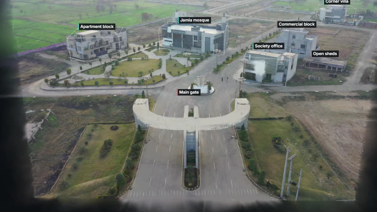
A developer selling a commercial block is asked the same questions every day: who has which floor, what can still be built, where will people park, is it safe, and what will the electricity cost. We took 16 seconds of stock drone footage over the entrance of a housing society in Pakistan, rebuilt it in 3D and measured every building from the 3D itself: footprint, height and floors. On top sits a sample register, every flat, shop and office marked sold with possession, on instalments, booked with token money, rented or still for sale, and the empty plots with what a by-law would let a developer build. Parking is set against what the buildings need, including the Friday rush at the mosque; sample cameras show what they can see; every roof gets its solar yield; and a sun study casts the buildings' shadows through the day, with north estimated from the mosque, which faces the qibla. From the drone's own position, a divider slides between the 3D and AI pictures of the empty plots a year on and built out.
What we tried
- One 16-second 4K stock clip flying in over a society's gate: 33 frames, every camera placed at 0.63 px, rebuilt in 3D with Spirula Studio (about a million splats).
- The ground found as the plane square to the drone's level camera and flight line; scale from two people walking by the roundabout, which gives storeys of 3.3 to 3.9 m as built.
- Each building outlined once by eye on one frame; the splats inside the outline, above the ground and at the building's distance, give its footprint and height, checked by drawing the box into other frames.
- The society's name on the gate, the office and the roundabout flattened out of the 3D, and blurred before any frame went to the AI.
- A sample register, by-laws, parking standards, cameras and solar yields laid on the measured buildings, and north estimated from the mosque's qibla wall for a sun study.
- Two AI pictures of the same drone frame, the empty plots a year on and built out, laid over the 3D from that frame's position.
What we measured
| Measure | Result | Note |
|---|---|---|
| Frames placed by the camera solve | 33 of 33 | 0.63 px average error, 16 seconds of footage |
| Scale | 28.0 and 28.8 | metres per model unit from two people; about plus or minus 8% |
| Buildings measured | 6 and the gate | heights 2.4 to 11.8 m, storeys 3.3 to 3.9 m |
| Empty land traced | 3,196 m2 | four plots, about 126 marla |
| Society name removed | 3 signs | about 27,000 splats flattened |
| AI pictures | 2 for $0.14 | drawn on a real frame with the name blurred |
| Browser download | 15 MB | the 3D |
What went wrong
- The clip is titled a modern office, but the sign on the big glass building says it is the society's main mosque. The page calls it what its sign says.
- Heights at first came out far too low: under a building, the lowest solved points are its roof, so the ground was lifted with it. Heights are now taken from the ground plane, as the site is flat.
- Flattening the colour of the name's splats left the letters readable, because they also live in how opaque the splats are; the opacity had to be evened out too.
What happens next
- A developer's own register, by-laws and approved drawings in place of the samples.
- A longer flight round the block, so every side is sharp and can be scored against held-back frames.
- A flight a month, so the grey-structure block and the empty plots show what has really been built.
Built with
- Spirula Studio (3D reconstruction) Spirula Studio terms
- Gemini image model (future views) Google API terms
- OpenCV Apache-2.0
- Spark 2.2 MIT
- three.js MIT