- 1 · Payments
- 2 · Build stage
- 3 · Checks
- 4 · Timeline
- 5 · Works
- 6 · Files
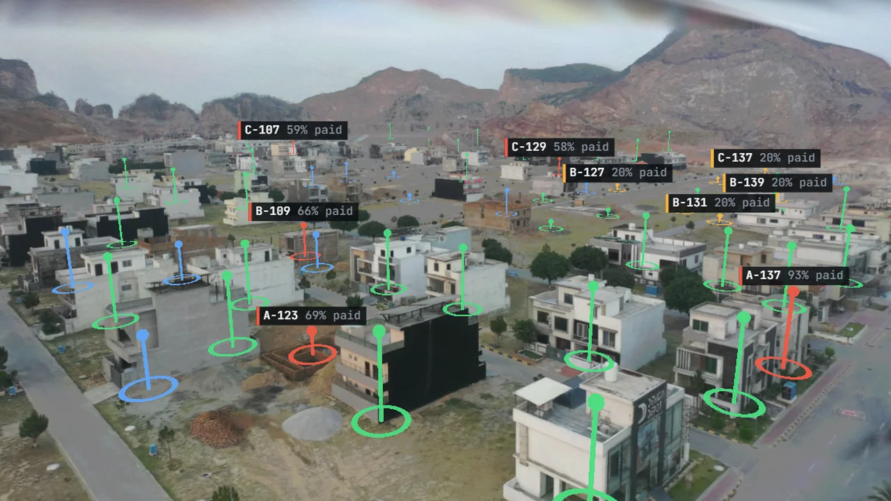
Housing societies sell plots on paper and build them over years, and the questions never stop: is my plot where my file says, has my house started, who has paid, where is the park from the brochure. We rebuilt a corner of a housing society in Pakistan in 3D from one stock drone clip, found every building and read how far each has got in the local terms buyers use (foundations, grey structure, finished), and marked the empty plots. On top sits a register of owners, files and payments, so the map shows what every owner has paid, who has possession, and where the records and the ground disagree: a house on a plot the register calls unsold, a park on the plan with a house on it, building going up while instalments are months behind. Every plot has a passport. A works layer traces the roads from the footage and runs a sample plan of water, sewer, electricity and Sui gas along them, with each block's progress and where work goes next; a build timeline scrubs three years, each building rising out of the real model in turn and the plan for the empty plots rising as holograms.
What we tried
- A 20-second 4K stock clip over a housing society in Pakistan: 82 frames, every camera position solved, rebuilt in 3D in about 40 minutes on one RTX 4070.
- An AI detector found buildings in every frame; sightings of the same building became one pin where it stands. 57 places, 5 of them rooftop close-ups or road edges.
- Every building labelled by eye from its best view, in the stages Pakistani buyers use: foundations, grey structure, finished.
- A local vision model asked two yes/no questions per building, fixed before each run, and scored against the eye labels.
- Thirteen empty plots and four roads marked by eye on one frame and placed on the ground by casting each mark onto the solved site floor; each building's height measured against its own local ground, because the society sits on a slope.
- Material heaps from the same detector, checked by eye: 3 of 8 were real heaps, and only those are shown.
- A build timeline that cuts every building down and grows it back out of the real model, block by block, and holograms for the plan beyond today.
- A seeded sample register (owner, city if abroad, plot size in marla or kanal, price in PKR, instalments, file status, allotment letter) with a few records set to disagree with the ground on purpose, and checks that compare the two.
What we measured
| Measure | Check | Result | Note |
|---|---|---|---|
| Frames placed by the camera solve | — | 82 of 82 | 0.45 px average error |
| Held-out frames, rebuilt vs real | — | 38.1 dB PSNR | SSIM 0.973, LPIPS 0.050 |
| Buildings found | — | 52 | plus 13 empty plots marked by eye |
| AI stage reading vs eye labels | 75% (always finished) | 83% | 10 of 13 unfinished buildings right |
| First question tried | — | 37% | asked about glass in the windows; called most finished houses unfinished |
| Time to read every building | — | 97 s | on one graphics card, nothing sent to the cloud |
| Browser download | — | 14.4 MB | the whole society in 3D |
What went wrong
- The first stage question (plastered walls and glass in the windows) scored 37%: from the air the model could not see glass, so it called most finished houses unfinished. Asking about the wall surface alone fixed most of it.
- The vision model no longer fit on the card beside the desktop and stalled for minutes; part of it now runs from system memory, slower but steady.
- Close-up views away from where the drone flew break up, so every camera move in the demo closes in along a line from a real drone position.
What happens next
- A society's own layout plan and register instead of sample data, with plot outlines from the approved plan.
- Monthly flights, so each plot's passport shows its build over time.
- A picture of the finished society lifted into 3D in place, as in the Giza demo.
Built with
- Qwen3-VL-4B (stage reading) Apache-2.0
- Spark 2.2 MIT
- three.js MIT